DPW PHOTOMOD

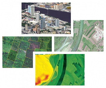
PHOTOMOD provides a closed production cycle, and involves the generation of many kinds of value-added products: digital maps, DEM, orthomosaics, 3D-vectors without the use of third party solutions. The PHOTOMOD software complex is used in all areas where metric information about the Earth with maximal precision is required.

DPW PHOTOMOD
DPW PHOTOMOD
The newest version: 7.5.4243 ×64
Download the version
Download Lite-version
Phototriangulation
Digital terrain model
Orthorectification
2D and 3D vectorization
3D-modeling
PHOTOMOD capabilities
  • Wide range of supported sensors.
  • Multiple data exchange formats for compatibility with photogrammetric and GIS products by other makers.
  • Comprehensive quality control at all stages of data processing.
  • Wide choice of stereoviewing options: LCD glasses or screens of various vendors with page-flipping modes, as well as simple anaglyph glasses.
  • Support for a variety of input devices: 3- and 5-button mice, specialized 3D controllers.
PHOTOMOD capabilities
PHOTOMOD advantages
PHOTOMOD advantages
  • Complete image data processing workflow without third party products.
  • High level of automation for main photogrammetric operations.
  • Flexible modular architecture: you only buy what you need.
  • Distributed network configurations for large projects implementation.
  • High productivity and reliability.
  • Very affordable prices.
Support and Training
  • Ease of use: you are guided step-by-step through all stages of project processing.
  • Prompt and effective technical support.
  • Chinese, English, Greek, Russian, Spanish localizations.
  • Full user manual.
  • An international dealer network helps us to market, sell and support our products in 80 countries.
Support and Training
Configuration
PHOTOMOD’s flexible modular architecture and powerful import/export tools permit a variety of configurations. Temporary version and time-limited licenses are available.
Local version. Powerful system for any tasks.
Network version. Unlimited workplaces for industry tasks.
PHOTOMOD @ GeoCloud and cloudeo cloud-services.

Formation results

If you select more than 1 license, the displayed price is NOT multiplied, because we have a system of discounts for every second, third, etc. When creating the Order, a field with the number of licenses should appear and the inscription: "The given price corresponds to the cost of one license, the calculation of the full cost of the order is made by the company's specialists according to the discounts: 2nd copy - 10%, 3 copy is 12.5%, 4th copy is 15%, 5th copy is 17.5%, 6th copy is 20%, more is available on request. "
There are no results, try to specify other input and output data.

Spatial aerial triangulation

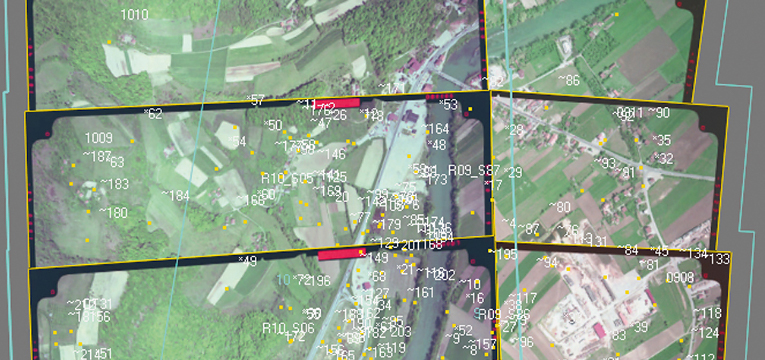
The functions of the aerial triangulation in PHOTOMOD are required to accurately calculate the orientation parameters of images and provide a high geometrical accuracy of the output products: DEM, orthomosaics, digital maps. Arial triangulation results (orientation parameters) are calculated automatically, and the system provides a full range of tools for accuracy evaluation, visual control and errors analysis.

Digital terrain models

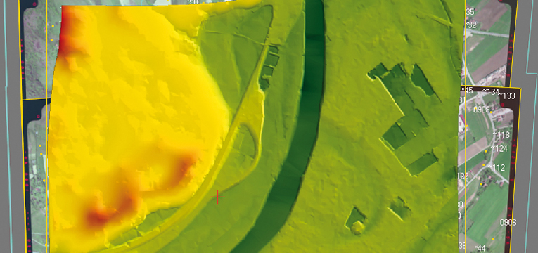
PHOTOMOD allows the user to automatically create digital elevation models and digital surface models from aerial and satellite images. The digital terrain model created in PHOTOMOD ensures high quality of orthomosaic, and also serves as a source of detailed information about terrain relief and is used to solve analytical tasks.

2D and 3D-vectorization

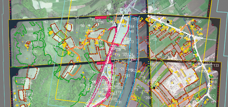
The PHOTOMOD system supplies the user with a full set of tools for 2D and 3D-vectorization and editing of drawn terrain objects. You may use vectorized objects as a topographic basis of cartographic products or input them as initial data to create mathematic (geometric) model scene during terrain 3D modeling.

Orthorectification and mosaic creation

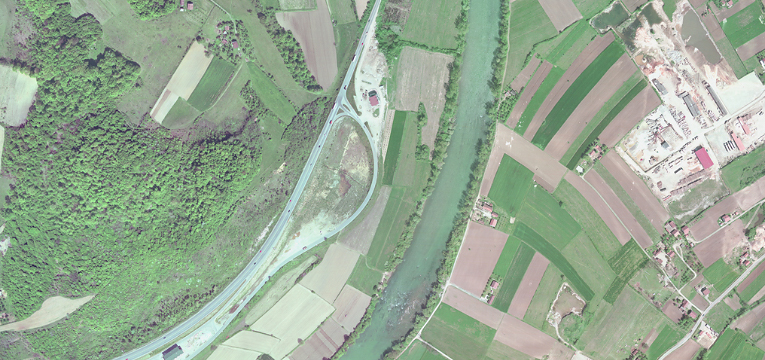
During mosaic creation using PHOTOMOD tools you can build continuous, color balanced and brightness homogenous orthomosaic with high accuracy from separate images. Geometric and photometric distortions are adjusted during the creation operation. Output product (orthomosaic) could be presented as a single frame or a set of sheets in specified cartographic projection with marginalia.

3D-modeling

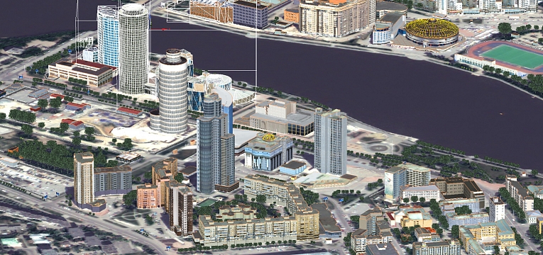
The PHOTOMOD software package includes features for creation of 3D models using stereovectorization results. The resulting model, due to the high quality metric may be used for solving applied analytical problems. And thanks to the visual appeal and clarity they may be useful when creating a vivid and compelling multimedia presentations and videos.


PHOTOMOD is a modular system. This allows users to obtain maximum benefit from its high level of flexibility. Each module performs specific operations during a certain stage of processing. Configure for optimal system production. Buy only the modules you need for your particular workflow. Easy operation. User interface of each module is optimized for module functions. Still, general interface elements remain uniform throughout the system.

The fundamental concept of PHOTOMOD is to enable projectwork through a series of well-defined steps (data preparation, block adjustment, processing) and provide the support of a flexible set of tools at every stage.

The PHOTOMOD System includes its main operating shell, PHOTOMOD Core, and 10 other modules:

  • PHOTOMOD Core — main system shell 
    Main system shell is used to initiate PHOTOMOD modules, manage projects, load images, enter camera parameters, view/import/export DTM, vectors, and triangulation points, create block layouts based on various source datasets, mono-vectorization, operate objects in 3D window, create reports, etc.

  • PHOTOMOD AT — aerial triangulation measurements
    Aerial triangulation data collection includes interior/relative orientation and ground control points measurement. Fully automatic tie points measurement algorithm with a comprehensive set of accuracy control tools is available. Almost no manual tie points editing is needed following the AT automatic procedure.
    More

  • PHOTOMOD SolverA — block adjustment for central projection images
  • PHOTOMOD SolverS — block adjustment for satellite scanner images
    SolverA and SolverS modules are used for block adjustment of central projection and scanner satellite images, respectively. Sophisticated adjustment and error detection algorithms ensure successful aerial triangulation and highly accurate DTM, orthomosaic and vector map output. PAT-B format import/export of aerial triangulation results allows PHOTOMOD software to easily integrate with other systems.

  • PHOTOMOD DTM — DTM & DEM creation
    The module provides a set of tools for creating DTMs. It produces Triangulated Irregular Network (TIN) and Digital Elevation Model (DEM). The utilities allow detailed work with pickets and contour lines, include automatic DTM creation algorithms, rebuild TIN and contour lines “on-the-fly,” contain a number of powerful DTM filters and manual editing tools. Final DTM can be viewed and analyzed in a special 3D window.
    More

  • PHOTOMOD dDSM — dense DSM generation algorithm
    PHOTOMOD dDSM enables to build dense digital surface models with a cell size corresponding to 1 pixel of image (Semi-Global Matching (SGM) method.).
    More

  • PHOTOMOD StereoDraw — 3D feature extraction in stereo-mode and 3D modeling
    This module is used for 3D feature extraction. StereoDraw contains a number of useful features: automatic terrain following, fix cursor Z-coordinate, snap to 2D and 3D vector elements, right angle plotting of line segments, combine vector objects by creating common parts, creation buffer zones, and more. Classifier table attributes can be assigned to vector objects. Import/export is supported for a number of popular data formats. Additionally, the module includes a 3D modeling program used before exporting objects to DXF format.
    More

  • PHOTOMOD Mosaic — orthomosaicking
    Mosaic module is used for orthorectification and mosaicking of aerial or satellite images. The module utilizes either terrain models from the PHOTOMOD DTM module or DEM imported from popular formats. Easy-to-use cutline editor outlines image fragments to be placed into mosaic. Color balancing and seam feathering algorithms provide high radiometric quality of the created mosaic. PHOTOMOD Mosaic automatically controls orthomosaic accuracy through the use of triangulation points. The output orthomosaic can be saved into GeoTIFF format or georeferenced by text files acceptable to MapInfo and ArcINFO. The splitting of orthomosaics into map sheets is also supported.
    More.

  • PHOTOMOD StereoMeasure — forest valuation
    PHOTOMOD StereoMeasure — a toolset for forest valuation: stereointerpretation and stereomeasurement of forest’s characteristics, as well as stereovectorization of forest stands based on remote sensing data. Existing PHOTOMOD projects and pairs of georeferenced orthorectified images (aerial and pushbroom scanner ones), having a mutual overlap are the input data for StereoMeasure module.
    More

  • PHOTOMOD ScanCorrect — geometric calibration of desktop publishing scanners
    This stand-alone module is designed for geometric calibration of desktop publishing (DTP) scanners. Through its enhanced scanner calibration procedure, the program enables to use of inexpensive scanners in precise digital photogrammetry applications. Scanned images are geometrically corrected in contradiction to a reference template image (a grid of crosses superimposed on the working image) scanned by the same scanner. Distortion caused by low-cost scanner optics and mechanics are removed in this process and virtually error-free images are produced.
CPU Intel Core i7
Memory (RAM) 32 ГБ (min 2 ГБ)
Graphics card Recomended Nvidia Quadro T1000.
Due to Windows 10 updates drivers of outdated video cards Nvidia Quadro are not supported anymore. Outdated video card series are those that are not produced any longer, such as Quadro FX, Quadro K, Quadro M and Quadro fr om 410 to 6000 (without letters). The main disadvantage of those video cards is that they do not have the page-flipping stereo regime in the PHOTOMOD programme. Some cards of these series still have the stereo mode available for PHOTOMOD software, however it is likely to become unavailable after Windows 10 updates. In order to avoid problems while in the stereo regime, we recommend using video cards of Quadro T, Quadro P and Quadro RTX series. No issues have been detected while in the stereo regime for any video cards in case of using Windows 7. 
Display Professional stereomonitors
HDD/SSD 4 Тb
Operating system Microsoft Windows 8.1, 10 x64

USB port should be available for hard lock key (for local PHOTOMOD version), or network connection to a server wh ere the key is installed if network PHOTOMOD version is being used.

Illustration_3.jpg

User manual Short description PHOTOMOD module/program
  • Installation of PHOTOMOD system.
  • Hardware requirements.
  • Creating resources system and management of profiles.
  • PHOTOMOD Raster Converter.
  • Tools for work in stereo.
  • GUI and Main system windows.
  • Distributed processing.
  • GPS.
  • Core
  • System Monitor
  • Control Panel
  • Raster Converter

Coordinates transformation form one coordinate system to another. GeoCalculator
Configuring system settings. Core

  • Project creation:
    • type of project,
    • coordinate system,
    • data placement,
  • Block creation:
    • converting images,
    • loading images,
    • images settings,
  • Project management.

Core

  • Entering camera data.
  • Performing interior orientation.
  • Input / measurement of GCPs.
  • Performing relative orientation.
  • Import / Export of:
    • triangulation points,
    • elements of exterior orientation.


AT
  • Adjustment of central projection image blocks.
  • Adjustment of scanner blocks.
SolverA
SolverS

  • 2D and 3D feature extraction 

StereoDraw
  • Building DEM, 
  • Calculating 3D-points,
  • Building TIN,
  • Building of smooth contours.

DTM
3D modeling. 3D-Mod
Processing of UAS data. PHOTOMOD UAS
LIDAR data processing. DTM
Building orthophoto and accuracy control.
Mosaic
  • Brightness adjustment.
  • Splitting into sheets.
Mosaic
GeoMosaic
Compensation of metric errors occurred when scanning graphical data on flatbed polygraphic scanners.
Core
Stereo interpretation and forest taxation PHOTOMOD StereoMeasure
Using hotkeys while working in the system.
Core
Installation of EGM2008 geoid.
Core

PHOTOMOD 7.4.4157-7.5.4243

22.12.2023 | pdf.gif Download

New functions
General
  • Training and classification of point cloud using neural network algorithms
  • Ergonomic improvements of the Area to cutlines addition mode
  • A capability to select GPU used in the Distributed Processing Monitor
  • Automatic texturing of vector 3D models with using images from a project
  • New tools of texture editing in PHOTOMOD 3D-Mod

Aerial triangulation
  • Display more than 12 cameras in the «Self-calibration parameters» window

Satellite imagery
  • Support of the new version of the SkySat sensor
  • Support of the «Zorky-2M» sensor
  • Fixed error of opening ArmSat-1 sensor images in «Radiometric correction» window
  • Fixed error of reading the metadata of the SuperView sensor

Orthorectification and mosaics
  • Building cutlines at a given Pyramid level of images
  • Option to show «Name only» for image in «Cutline info» windows
  • Fixed error of orthorectification for JPEG images
  • Fixed the operation of the «Cut images by DEM» function when of orthorectification of the images

Digital terrain and surface models
  • Batch export of DEM to a point cloud
  • Saving the selected group of points in the cloud to a separate file
  • Changing the height of the DEM to the value from attribute of the selected polygon
  • A capability to select a type of palette for coloring the DEM
  • Saving the classification when converting the DEM to a point cloud
  • The function «Select unclassified points only» for a point cloud
  • New value for the «Point Class» attribute — «Transport»
  • A capability to Set classification to none for a selected group of points in the clouds
  • A capability to adjust the transparency of the Classification and Color of a point cloud
  • A capability to remove part of the selection in DEM editing mode
  • Optimization of work with the selecting point cloud area by a polygon
  • Improved the automatic selection of a group of points in the cloud at high zoom level
  • Fixed the operation of «Selecting points by polygon»
  • Fixed 3D-TIN texturing using a point cloud
  • Fixed error in compute volumes between DEMs
  • Fixed error in assigning the height of the DEM from the height of the selected polygon

Stereovectorization
  • Fixed error where attributes with the value "0" were unavailable in «Autofilled layer attributes» windows

3D modeling (PHOTOMOD 3D-Mod)
  • Fixed error exporting a 3D model with a Light source to JSON format

PHOTOMOD AutoUAS
  • Separate button for viewing the Processing Report
  • EGM2008 geoid supported
  • Fixed error where Processing report was not displayed when deleting Temporary data folder

Distributed processing
  • Fixed error when Distributed Processing Client would not reconnect after shutting down the Server located on another PC

Raster Converter
  • Fixed error when four-channel image was incorrectly converted to a three-channel image

PHOTOMOD GeoCalculator
  • Updated PHOTOMOD GeoCalculator interface
  • Support for exporting topocentric coordinate system from GeoCalculator in *.x-ref- system format
  • New version of GeoCalculator is integrated into DPW PHOTOMOD
  • Loading Coordinate system from the GeoCalculator database into the DPW PHOTOMOD
  • Fixed error when additional Coordinate System transformations were not taken into account when exporting to *.x-ref-system format
  • Fixed incorrect zone number in the cartographic projection for MSC-87 zone-4
  • Fixed error when geoids were not taken into account when calculating

Project Manager
  • Import and Export functions to Cutlines" and "Sheets" submenus in GeoMosaic
  • Optimized the appearance of several tool windows
  • Automatic recalculation PHOTOMOD working area in the case of conversion into another coordinate systems
  • Common EGM2008 geoid for DPW PHOTOMOD and PHOTOMOD GeoCalculator
  • EGM2008 geoid supported for Linux operating system

    • PHOTOMOD 7.3.3768-7.4.4125

      11.09.2023 | pdf.gif Download

      New functions

      General
      • Measurements of tie points using GPU (increasing the productivity)
      • New function of DEM editing — deleting local selected objects (buildings, etc..)
      • A capability of co-editing of vector objects by several operators
      • New algorithm for blunder detection and the error distribution for the projection centers
      • PHOTOMOD AutoUAS for Linux operating system
      • Speeding-up of automatic tie point measurements for oblique UAS survey
      • Interactive classification of the point cloud
      • Editing tools for the point cloud
      • Set of Pan-sharpening improvements
      • Boolean operations on objects in 3D-Mod

        Aerial triangulation    
      • New configuration of the Feature-based correlator — "Nadir oblique Camera"
      • New configuration of the Feature-based correlator — "Optimal 2"
      • A capability of reducing stereopairs number when tie points measurements (speeding up)
      • Added the “Tie-points statistics” table to the block processing report
      • Offset from image boundaries parameters (Feature-based correlator)
      • Support of camera passport in Pix4D format
      • Processing of a project that uses different cameras inside the strips
      • Import GCPs coordinates and measurements from Trimble Inpho
      • Fixed display of images in the Block processing report in the project with the left coordinate system
      • Fixed the error where the GSD was not for the project in the local coordinate system
      • Fixed error where the Feature-based correlation used the wrong order of images in the strip
      Satellite imagery
      • Minimization of the effect of erroneous measurements on the results of adjustment
      • Hierarchical RANSAC algorithm (acceleration of tie points measurements)
      • Using the feature-based correlation for Pan-Sharpening
      • New options in batch Pan-Sharpening: deleting selected images, skipping created images
      • Bias and affine options for measuring tie points (Pan-Sharpening)
      • Multi-treading mode for the adjustment with the "optimization" option enabled
      • Rejection of tie points in projects without metadata
      • Fixed the error of reading Pan-sharpened images when using uppercase in the path
      Digital terrain and surface models
      • Automatic filling of "holes" when using the interactive "Filtering object" DEM filter
      • Speed-up TIN editing
      • Changing the default parameters when building SGM
      • Selection of point cloud tiles
      • Improved the operation of the point cloud smooth filter
      • Automatic deletion of empty point cloud tiles
      • Interactive selection of adjacent points in the cloud of the same class by mouse click
      • Interactive selection of a point cloud area by a polygon
      • Considering of invisible zones when selecting a group of points in the cloud
      • Multi-step undo while point cloud editing
      • Parameters of DSM interactive filtering in the form of a drop-down window
      • Limit of the Z-range when calculation of 3D-points for small images
      • Fixed volume calculation error when using multipolygon
      • Fixed error when building TIN within selected polygons
      Stereovectorization
      • Arithmetic operations with attribute values
      • Building buffer zone parallel to selected line in the form of a polygon
      • Moving a vector object to a height from an attribute
      • Export of vectors via Layer Manager
      • А cаpability of saving object heights above DEM to attribute
      • The function of making measurements on the ellipsoid of the working coordinate system
      • “Replace selected segment by fragment from other layer” function
      • Function “Make vertices linked/unlinked” for the selected vertices
      2D and 3D windows
      • Building histogram for project images
      • Limiting the number of images in the “Open images under marker” function
      • Fixed the display of TIN edges in stereo mode
      Orthorectification and mosaics
      • Option of minimal overlap of images, which allows to limit the cropping of the image
      • Setting the range of background color shift on the raster in case of coincidence with the orthomosaic output background color
      • Linking cutlines without attributes to images in (by coordinates)
      • Writing transparent background color in PNG format
      • Speed-up the creation of the mosaic when using “work-region” polygon
      • Capability to specify number of pixels beyond the frame of the DEM when cutting into sheets
      • Speeding-up the process of preparing the launch of cutlines building
      • New function — replacing selected node by the new cutline
      • An option of displaying the general progress bar
      • Checking background color of source images by channels
      • Fixed error of building detailed cutlines for orthophotos with lat-lon georeference
      • Fixed error of incorrect brightness adjustment with the "match histogram" and "by average brightness" parameters
      • Fixed error where the link to the image source was not saved in the properties of cutlines
      3D modeling (PHOTOMOD 3D-Mod)
      • TIN texturing by selected rasters
      • Export of 3D-model to Multilevel Geometry json format
      • “Cut fragment” function for georeferenced image
      • Speed-up the building 3D-TIN process by DEM
      • New 3D-TIN texturing options
      TrueOrtho
      • Additional parameters of TrueOrtho pixel color calculation
      PHOTOMOD AutoUAS
      • Using GPU for automatic measurements of tie points
      • New chapters in the Block processing report
      • Viewing rasters and DEMs in the 3D window
      • Improved the 3D-window interface
      • Support of *.tx3 format for 3D-models
      • Improved building of TIN by LAS
      • Added general progress bar of the process
      • Fixed the error that occurred when using Cyrillics in the project paths
      • Fixed the error when writing a Block processing report in *.html format
      PHOTOMOD Conveyor
      • Added the Feature-based correlator for satellite projects
      • New installer
      • Restart individual tasks after error messages
      • Changed default settings for the most efficient processing
      • Auto start distributed process center at program startup
      • Warning about deleting project/output files
      • Fixed the function of pixel automatic calculation in the output DSM
      Distributed processing
      • Automatic closing of the distributed processing monitor when updating the PHOTOMOD version
      • Creating Data Base for the distributed processing during the first PHOTOMOD installation
      • Step-by-step removal of successfully completed distributed processing tasks when working with large projects
      Raster Converter
      • Support of *.bil and *.bip formats
      DustCorrect
      • Fixed the error of displaying images when the background color is incorrectly specified
        Project Manager
      • Optimized the appearance of several tool windows
      • Modifications of pre-regions building algorithm
      • The sequence of ADS images taking into account the Forward-Nadir-Backward property
      • Improved news list
      Import and Export
      • Recording tiles *.prf in GeoTIFF format
      • Support of the WEBP format for output raster data
      • “Deflate” compression algorithm for images and DEMs

      Change log 7.2.3544-7.3.3768

      14.12.2021  |  Change log

      General

      • Coloring an external LAS point cloud based on project imagery
      • Creating DEMs and TrueOrtho based on external LAS point cloud in PHOTOMOD AutoUAS
      • 3D-model building speed-up using LAS by DEM
      • Transforming LAS into a DEM and TrueOrtho
      • Additional distortion coefficients during self-calibration
      • Changes in the algorithm of bridge inserting during orthorectification
      • Modifying the Voronoy diagram’s calculation algorithm during orthoimage creation
      • Point filtering according to the results of preliminary adjustment (object-oriented calculator)
      • Joints DEM filtering by slope angle and NDVI/NDWI-indices
      • NDVI-index recording into the LAS point cloud if the IR-band is available in project imagery
      • New 3D-window. A prototype.
      • A prototype of an image classifier using NDVI
      • Merging rasters into a file from separate file-bands using a correlator
      • Support of new Chinese sensors (satellite imaging data processing)
      Aerial triangulation
      • Optimizing automatic search for tie points with the option "search over the entire image" enabled
      • The option “Not to consider points ‘without adjustment’" in the relative orientation report window is available
      • A list of cameras with their calibrated values is included in the “Block processing” report in case of several cameras.
      • TerraPhoto camera format support
      • Assigning a new camera to images after adjustment with self-calibration
      • Improved Block processing Report
      Satellite imaging
      • Reading IR-band numbers from satellite image metadata
      • Priority of RPC coefficients when using georeferencing in Pan-Sharpening
      • Exporting image RPC-coefficients into .RPB
      • Correct recognition of the Kanopus satellite 4A level
      Digital terrain and surface models
      • DEM building speed-up by LAS point cloud
      • Modifying dense DEM building (SGM method) in cases of strong GSD change along a stereopair (near and distant views)
      • Vegetation recognition by the IR-band when creating a dense DEM (SGM method)
      • Considering the existing LAS point cloud classification in the Averaging filter and LAS Interpolation
      • NDVI calculation statistics (histogram)
      • Displaying information on the selected point in the LAS-viewer window
      • Available “Maximum number of adjacent images” option when creating a LAS point cloud
      • A pyramid calculation speed-up in distributed DEM building processes
      • Fixed incorrect display of DEM NULL-values in the 3D window and the 3D-Mod window
      • Fixed error in calculating the embankment volume when comparing two DEMs
      • Exclusion of selected classes from DEM
      • Preliminary interpolation of a point cloud improving the geometry of smooth objects when creating 3D-TIN
      Stereovectorization
      • Selection of vector objects according to their spatial mutual arrangement
      • New options to the "Objects around Vertices" command

      2D and 3D windows
      • Polygon area calculation taking into account the 3rd coordinate
      • Raster layer download in a 3D-window speed-up
      Orthorectification and mosaics
      • Orthorectification speed-up when inserting a large number of vector objects
      • Changing the algorithm for accounting for invisible zones
      • GeoTIFF tags in GIS Panorama (GSK-2011/PZ.90-11) when orthorectifying are added
      • Assigning names from attributes when creating sheets in GeoMosaic
      • Optional adding text suffixes and prefixes to the names of selected sheets in PHOTOMOD GeoMosaic projects
      • Accounting for areas without background when selecting images by marker position

      3D modeling (PHOTOMOD 3D-Mod)
      • Configuring detailing level when using the “Transform into a grid” tool
      • Object centering
      • Supporting COLLADA objects
      • Supporting models of *.DAE format.
      • Fixed a bug that occurred when exporting models to OBJ format with an output file of more than 4 GB
      • Optimized Export to .DAE format Options window
      • Automatic calculation of the geometry center of OBJ models when importing into PHOTOMOD 3D-Mod to improve the quality of model displaying

      TrueOrtho
      • Additional options for TrueOrtho global adjustment
      • Options for selecting color of TrueOrtho pixels based on source rasters 
      PHOTOMOD AutoUAS
      • Recalculating external (LAS) point cloud into the project’s coordinate system
      • Interface improvement
      • Added buttons to launch Viewer and 3D-Mod
      • Distributed processing autorun when launching the program
      • External camera support in PHOTOMOD format
      • Ability to export 3D-TIN model to open in Cesium

      PHOTOMOD GeoCalculator
      • Supporting import and export coordinate systems with XML format for external PHOTOMOD GeoCalculator
      PHOTOMOD Conveyor
      • MegaTIFF image support
      Raster Converter
      • Fixed algorithm for updating metadata files during converting
      Project Manager
      • Distributed addition of ADS images to the project via Raster Converter
      • Copy paths in the control panel

      Import and Export
      • Exporting vector objects (points) into .LAS


      Change log 7.1.3505 - 7.2.3544

      14.12.2021   Change log

      New functions

      General

      • Point cloud (LAS) calculation from satellite imagery

      • Point cloud calculation from ADS data

      • Satellite images projects. Tie point measurements reliability is significantly increased

      • On-line notifications about new functions and fixed errors

      • Multiband images support for every stage of photogrammetric processing

      • Color balancing on AT processing step with further using in the output products

      • Bundle adjustment. Systematic errors calculation “along flight direction”

      • Orthomosaicking. Cutlines algorithm modifications

      Aerial triangulation

      • Speeding up distributed tie point measurements

      • Block layout correction in cases of “horizon-oriented” images (very oblique)

      • Feature-based algorithm for ADS data

      • Using project layers for automatic GCP measurements (from ortho and DEM)

      Satellite imagery

      • Batch mode for Pan-sharpening while the project creation

      • PeruSat sensor support

      • “Preliminary block adjustment” option for blunder detection.

      Digital terrain and surface models 

      • New point cloud filters

      • Batch 3D TIN creation for PHOTOMOD project currently opened

      • DEMs “comparison” inside selected vector polygon

      • DSM median filter acceleration

      • Modifications of LAS normals calculation algorithm

      • Bilateral DEM filter as a separate operation

      • Optimization temporary data deleting while DSM building

      3D feature extraction 

      • User-defined length / width parameters for “rectangle” CAD object

      • Attribute type selection when writing Z values above DEM to the attribute

      • Merging vector resources with classifiers

      • New parameters of “objects around points” operation

      • Color inversion capability in the stereowindow

      Orthorectification and mosaic 

      • New parameters of useful areas creation process

      3D modeling (PHOTOMOD 3DMod)

      • Work area external texture support (clouds, sky, etc..)

      • New tool of edge selection when changing grid and texture coordinates

      • Batch 3D-TIN (json) export to popular formats

      • Export of 3D-TIN to Cesium 3D Tiles format

      • Error in 3D-TIN export with coordinate system recalculation is fixed

      TrueOrtho

      • Color balance improvements

      • The error of filling holes in grayscale TrueOrtho is fixed

      DustCorrect

      • MSTIFF and MegaTIFF (no compression) formats are supported

      • An option «do not change time/date» while editing is added

      Import-export

      • Batch export of resources of not-open project

      • Keeping type of control / check / rejected points (import of measurements)

      • Saving Z-coordinate to “Elevation” code (export to DXF)

      • Batch export. Capability of coordinate system recalculation

      PHOTOMOD AutoUAS

      • User-defined RMS of projection center coordinates

      • Export of 3D-model to Cesium format

      Change log 7.0.3323 - 7.1.3505

      26.07.2021 

      General
      • PHOTOMOD AutoUAS – new software for fully automatic processing of UAS images with the simplest interface
      • PHOTOMOD StereoClient - new application for remote work in professional stereomode
      • Block layout independency of the aerial triangulation (AT for the flights of any complexity level)
      • Significant acceleration of point cloud (LAS) calculation
      • New LAS filters
      • New parameter presets for the aerial triangulation (feature-based correlator)
      • Better quality of tie points measurements for multitime images
      Coordinate systems
      • Greek coordinate system EGSA87 support
      • Support of IRENET95 / Irish Transverse Mercator (EPSG:2157) (ITM)
      Project creation
      • Reading flight height over the start point from XMP format
      • Speeding up of reading EO parameters from XMP format
      • Incorrect image sorting is fixed (loading images to the project in multithread mode) 
      Aerial triangulation
      • Different acceptable ratio focal length / survey basis for aerial and UAV survey
      • Selfcalibration algorithm improvements for big off-nadir angle imagery
      • Managing of number of stereopairs to be included into the adjustment report
      • Block layout corrections for the case of the survey with big angles range
      • 5-sensors MIDAS camera calibration problem is fixed
      • Speeding up of deleting duplicated tie points in the project
      • Selection of units and error types in the relative orientation report
      • RMS of measurements in UAV project is 0.5 pixels
      • AT algorithm modifications when several cameras are involved in one project
      • All tie points are used in the camera selfcalibration by n-plets
      • Automatic measurements of GCPs “taken” from the reference orthoimage
      • Automatic pyramid level selection in dependence on the image size (tie point measurements)
      Satellite imagery
      • Preliminary adjustment option when automeasuring GCPs from reference raster
      • Loading previously saved adjustment results for adjustment “by steps”
      • Pléiades Neo support
      Digital Elevation Models 
      • Dividing big point clouds into fragments while processing (speeding up)
      • Combining tasks of LAS blocks creation if the number of tasks is more than 500 (speeding up)
      • Undo for DEM editing operations
      • Using origin for dividing LAS into fragments (speeding up)
      • Partial implementation of multiray mode for DSM calculation
      • “Comparing” DEMs inside / outside selected polygon
      • Changes in DEMs comparing report
      • Grid for DEM calculation is located on the marker height now
      • Type of attribute selection when writing the height of the objects above DEM into the attribute
      • DEM control by vector object – writing selected attributed to the output csv-file
      • Error in batch import of DEM from MTW is fixed
      • Error in volume calculation in case of using TIN as a surface is fixed
      3D-feature extraction
      • An option of topological connectivity in roof-digitizing tools in order to make one output 3D-model for each roof when exporting
      Orthorectification and mosaic 
      • Corrections in the algorithm of bridges embedding into DEM
      3D modeling 
      • Batch export of 3D models to OSGB format
      • Modifications of the algorithm of building 3D TIN by DEM
      • Biltateral filtering in distributed mode
      • 3D TIN simplifications (less number of triangles) keeping the model quality
      • New default parameters of 3D TIN smoothing filter
      • New fast algorithm of filling holes in the 3D TIN
      • Mesh building algorithm changes
      • Measurements over 3D-model
      • Error of making 3D TIN from ADS data in case of big water areas is fixed
      • Error in export from tx3 to b3dm and json is fixed  
      TrueOrtho
      • Color balancing improvements
      • TrueOrtho process default parameters take into account DSM GSD
      • Speeding up of holes filling process
      • Additional accounting of tall objects
      • Error of writing 4th channel in case of 16 bit source raster is fixed
      Import-Export
      • Export of coordinate systems to RSW format
      • The problem of partial objects skipping in import from SXF is fixed
      Distributed processing
      • Auto calculation of number of simultaneously starts multithread tasks based on available RAM (DSM building) 


      Change log 6.5.2764 - 7.0.3323

      01.11.2020 

      General

      • More GPU support
      • PHOTOMOD UAS. Image size is up to 100 МП
      • Easy interface of images loading and block layout creation
      • Changes of distributed processing GUI
      • Fast commands icons in the upper part of main system window
      • Distributed processing optimization for NUMA architecture
      • System interface adaptation for low-resolution notebook screens

      Coordinate systems

      • Support of GOST 32453-2017 (including GSK-2011)
      • Calculations between MSK / SK-63 and WGS 84
      • Geocentric WGS-84 support

      Aerial triangulation

      • Significant acceleration of big blocks bundle adjustment by using the multithread mode
      • Radical changes of tie point measurement algorithm for UAS images in order to increase the quality
      • AT parameters presets for different type of territory (basically UAS)
      • Intellectual first approach for the bundle adjustment (independent models)
      • Increased adjustment reliability for “poor” data (not-stable angle and overlap values)
      • Speeding up the self-calibration
      • Import EO angle values from XMP-format
      • Simple and fast GCP searching over the block of images
      • Acceleration of tie points measurements for no-pyramid images
      • Speeding up parallax and triplets filtering
      • Importing camera passports from Metashapе and Pix4dReading and saving triangulation points catalog in multithread mode
      • A capability of adding the shift to projection centers coordinate values
      • Table with a list of images and corresponding triangulation points

      Satellite imagery

      • Displaying the azimuth value along with off-nadir angle in the window of manual tie point measuring

      DTM and DSM

      • New algorithm of the point cloud computing
      • DSM – DTM filter
        - New parameter – “Slope angle”
        - “Down” blunder detection
        - TrueOrtho using option
        - Several passes filtering for hilling areas
      • Fast filling the “holes” in DSM by using distributed processing
      • “Dividing” DSM and point cloud creation processes (by the appropriate options)
      • MI (Mutual Information) for DSM building
      • Point cloud filtering by data density
      • Automatic “penalty” values pre-calculation (DSM)
      • Displaying statistics of the point cloud and DEM
      • Building DEM for several areas, limited by the vector polygons
      • Median filter acceleration
      • DSM-DTM filtering inside or outside selected polygons
      • New interface of the “Histogram” window and increased speed of its calculation
      • Batch and distributed DEM transformation between the coordinate systems
      • A capability to manage output DSM precision
      • Profiles from DEM interface changes
      • New interface of volume calculation dialog
      • Embedding TIN to DEM possibility
      • Eхport of map projection/datum parameters to MTW format 

      TrueOrtho

      • 4 channels TrueOrtho
      • Rejecting pixels of big color distinctions

       3D modeling

      • Multiply speed up of 3D-TIN texturing
      • 3D-TIN smoothing tools while the texturing
      • 3D-TIN window changes
      • Export of 3D-model to multilayer OSGB format
      • Automatic TIN holes interpolation

      Vector editor

      • The grid-surrounding cursor in order to estimate the size of vectorization object
      • Import of 3D-face objects from DXF format
      • Export to DXF with 2D-option

      Ortorectification and mosaic

      • Cutlines algorithm corrections
      • Images loading acceleration in PHOTOMOD GeoMosaic
      • Additional options of datum / projection export to GeoTIFF

      PHOTOMOD Conveyor

      • Now it easy to install and start

      Change log 6.4.2295 - 6.5.2764

      22.11.2019

        New algorithm for the bundle adjustment:
      • significantly speeding up the adjustment for low quality block layout (big and instable orientation angle values),
      • full and smart automation detection of incorrect points,
      • modifications of the self-calibration procedure,
      • multithread calculations support.
        New distributed processing implementation:
      • speeding up of remote sensing data processing,
      • increasing the reliability and resistance to local network failures,
      • new user-friendly interface,
      • fast tasks managing, immediate task pausing and starting on remote client,
      • export and viewing of LOG-file directly in distributed processing window,
      • equal and consequent workloading of clients.
        Radical quality improvements of the 3D modeling and visualization:
      • DSM accuracy and details increased,
      • 3D-model layers and tiles implementation for fast and comfortable displaying,
      • increasing quality of texturing,
      • DTM – DSM conversion modifications,
      • enhancements of satellite imagery 3D modeling.
        New 3D-feature extraction tools:
      • more templates for roof digitizing,
      • combining, cutting and aligning of 3D vector objects. 
        Updated PHOTOMOD Conveyor:
      • Linux version,
      • REST API interface for cloud services,
      • New user-friendly interface.

      Change log 6.3.2179 - 6.4.2295

        General
      • Automatic generation of textured 3D-models (3D-TIN) based on DSM and point clouds (LAS)
      • 3D modelling for satellite imagery
      • New LAS filtering tools
      • Radical speeding up of satellite blocks adjustment
      • True Ortho and dense DSM improvements
      • Easing of PHOTOMOD UAS restriction on input image size to 80 MP
        Aerial triangulation
      • Extended capabilities for computing Kappa angles by flight direction based on oblique aerial survey data (Orientation/ Exterior orientation data list/ Compute kappa angle by flight direction/ More)
        Satellite imagery processing
      • Support of Aist-2D and PlanetScope imagery
      • Speeding up of satellite blocks adjustment (Adjustment parameters/ Images/ Enable optimization)
      • Extended capabilities to export RPC for projects adjusted with Affine refinement method Digital terrain models
      • Automatic generation of 3D-TIN based on DEM along with building dense DSM (Terrain/ DEM/ Build DEM/ Dense DSM (SGM method)/ Create 3D-TIN)
      • Automatic generation of 3D-TIN based on point cloud (LAS) and DEM (Terrain/ TIN/ Build 3D-TIN)
      • Interface simplification and speeding up of slope based filter (Terrain/ DEM/ Slope based filter)
      • Abilities to cut point clouds (LAS) by polygons and transform them from one coordinate system to another (Terrain/ LAS/ Cut LAS by polygons and Convert LAS coordinates)
        Vector editor and 3D-MOD
      • New modes for aligning and scaling vector objects (Edit/ Alignment mode, Edit/Scale when align, Service/Settings/Vectors/Change Z of aligned object)
      • New formats for export 3D models from 3D-MOD (.obj, .b3dm, .json, .gltf)
         GeoMosaic
      • Ability to consider invisible areas in clouds layer while building cutlines (Cutlines/ Clouds/Invisible areas)


Order form

Protection from automated form filling
Please type in the symbols shown in the image above*
* Required fields