DPW PHOTOMOD basic training courses
We offer three levels of training in use of the PHOTOMOD system:
Introductory one day training at the Racurs office in Moscow (English);
Basic training courses. General principles and main stages of the photogrammetric production line;
Advanced training courses in some specific applications such as topographic mapping, cadastral mapping, architecture and construction, etc.
Basic and Advanced training courses are usually 1 week long.
Training conditions
Cost
Discounts for group training:
- 2nd student — 10% discount,
- 3rd — 12,5%,
- 4th — 15%,
- 5th — 17,5%.
Duration 5 days
The cost of the courses includes:
- classroom lessons,
- learning materials,
- lunches,
- coffee breaks.
Leave application
Training Scheme
- 10:00-13:00 — demonstration and education
- 14:00-18:00 — practical working, questions.
Course program
General software and hardware configuration. Installation procedure. Functionality of main modules.
- PHOTOMOD Control Panel – PHOTOMOD system data structure
- PHOTOMOD Montage Desktop – main system shell
- PHOTOMOD Raster Converter – project images preparation
- PHOTOMOD AT – interior and relative orientation, automatic aerial triangulation
- PHOTOMOD SolverA – block adjustment for aerial images
- PHOTOMOD SolverS – block adjustment for scanner satellite images
- PHOTOMOD StereoDraw – 3D feature extraction
- PHOTOMOD DTM – DTM and contour lines creation
- PHOTOMOD dDSM - DSM creation with SGM method
- PHOTOMOD Mosaic – orthorectification
- PHOTOMOD GeoMosaic – seamless colour-balanced mosaic creation
- PHOTOMOD 3D-Mod – 3D modeling
PHOTOMOD Control Panel. Resources system
- Local profiles. Resources structure
- Recommended data organization
- Centralized management of profiles
- Network profile. Working in the local network
PHOTOMOD Raster Converter. Images preparation
- Raster Converter
- Formats supported
- Images conversion parameters
- Metadata of modern digital cameras
- Radiometric correction
PHOTOMOD Montage Desktop. «No project» mode
- Coordinate system selection
- Transforming vector and raster data to selected coordinate systems
- Loading georeferenced data
- Checking raster and vector data consistency
PHOTOMOD Montage Desktop. Creating project of type «Central projection»: film camera.
- Project creation
- Project type selection
- Coordinate system selection
- Adding images from files. Formats supported
- Film camera passport data
- Import of exterior orientation parameters. Direct georeferencing
- Building block layout
- Import of GCP and tie points measurements
PHOTOMOD AT. Interior and relative orientation
- Automatic interior orientation for images from film camera
- Automatic aerial triangulation
- Automatic aerial triangulation report
PHOTOMOD SolverA. Block adjustment in free model
- Adjustment parameters
- Accuracy control and blunders detection
PHOTOMOD AT. Exterior orientation
- GCPs measurement
- Using raster or vector maps for georeferencing
PHOTOMOD SolverA. Block adjustment. Exterior orientation
- Adjustment methods and parameters
- Adjustment report
- Graphics user interface
- Filters by using number of criterions
- Error vectors
- Adding and editing tie points
- Subblock adjustment
- Self-calibration
- Export to 3D-party software
PHOTOMOD Montage Desktop. Creating project of type «Central projection»: digital camera.
- Project creation
- Project type selection
- Coordinate system selection
- Adding images
- Digital camera passport data
- Interior orientation. Setting the axis direction
- Import of digital camera metadata
- Automatic block splitting into strips
PHOTOMOD Montage Desktop. Main toolbar.
- Main window
- Tool panels
- Hot keys
- Stereowindow. Stereopair selection. Stereomeasurements modes
PHOTOMOD StereoDraw. 3D feature extraction.
- Main module capabilities
- Classifier
- 3D vector objects related operations
- Objects editing
- Group editing tools
- Layers
- Snap-to-ground mode
- 2D and 3D snapping
- Topological operations
- Export to popular GIS and CAD formats
PHOTOMOD Montage Desktop. Main toolbar.
- Project management window
- Object backups
UAV data processing
- Import of GPS / IMU data
- Automatic tie point measurements
- GCPs measurements
- Camera self-calibration
PHOTOMOD DTM. DTM creation
- Building DTM:
- 3D points and breaklines
- TIN
- DEM
- Automatic 3D points calculation and filtering
- Smooth contour lines
- Creation
- Export
PHOTOMOD dDSM. Dense DSM creation with SGM method
- Building dDSM
- Filtering dDSM:
- Buildings and vegetation filter
- Slope-based filter
- Filling null cells
- Building 3d-point cloud in LAS format:
- LAS viewer
- Filtering 3d-points (LAS)
- Building True Ortho:
- Filling null cells
- Color balancing
- Creation 3D TIN by dDSM
- Creation 3D TIN by LAS
PHOTOMOD Mosaic / GeoMosaic. Orthomosaicking
- Mosaic project
- Seam lines building and editing
- Types of DTM used for the Orthorectification
- Color balancing automatic and manual tools
- Splitting into map sheets
- Preview window
- Orthomosaic accuracy control
- Distributed processing
- Orthomosaic from multispectral images
Distributed processing. Resources of PCs / CPUs in local network
- Distributed processing center. Setting up parameters
- Tasks creation, distribution and running
- Monitoring of distributed processing
PHOTOMOD Montage Desktop. Creating project of type Scanner satellite imagery
- Sensors and data formats supported. Input resolution and output scale
- Project creation
- Project type selection
- Coordinate system selection
- Radiometric correction for satellite images. Process parameters
- Rigorous and generic processing algorithms
- Ground control points requirements
PHOTOMOD SolverS
- Adjustment parameters
- Stereoblock processing options
- Accuracy control
PHOTOMOD Montage Desktop. ADS 40 and VisionMap A3 projects
- Coordinate system selection
- Dataset requirements
- ADS data preparation
PHOTOMOD 3D-Mod. 3D-modeling
- 3D feature extraction with classifier
- Vectorization rules
- 3D-Mod tools
- Texture covering
- Animation recording
- Export of 3D-models to DXF, COLLADA (.dae) and other 3D-vector formats
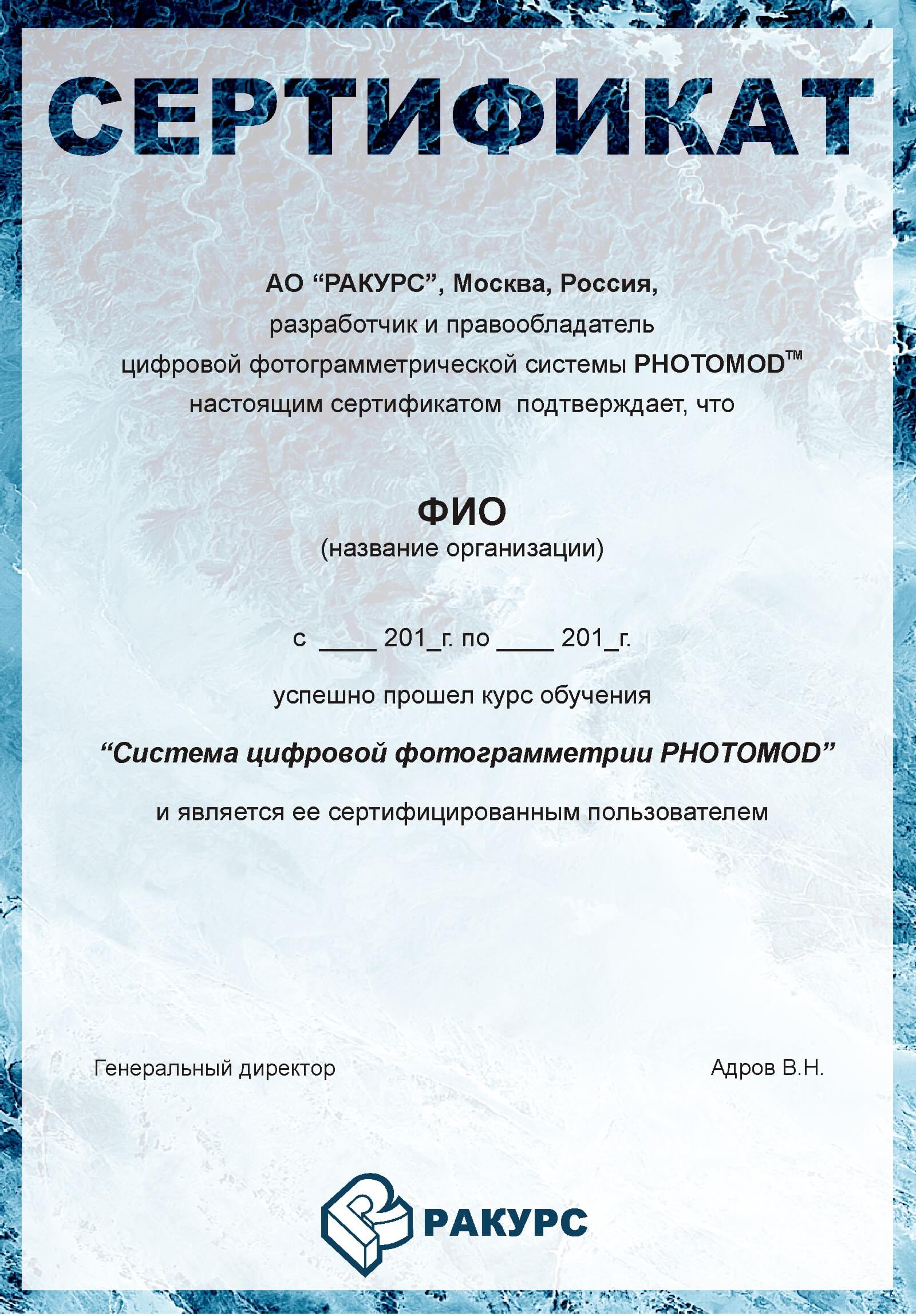
End Documents
Location
Yaroslavskaya Str., 13 A, Moscow, Russia
Training courses are also available from our dealers or on customer location
about the assignment to our managers